By bus, subway/metro, or train, get where you're going faster by being smarter with the Transit App for iPhone
The Transit App was lovingly, painstakingly designed and coded by Sam Vermette (of Shows) and Guillaume Campagna to make taking a bus, catching a train, or hoping on the underground as easy checking the weather or reading a social status. And they've succeeded brilliantly.
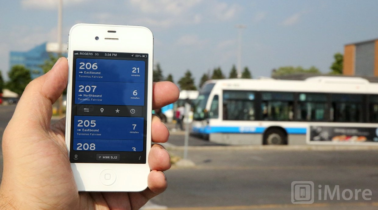
Launch The Transit App and it automatically detects your location, zones in on the public transport routes in your area, and shows you the next available times. Color coded. With icons. To match the transit system in your area.
The interface is big and blocky and almost Metro-esque, with small but delightful animations for things like time spinning down before your eyes (run!). Tap on one of the routes and options open up. You can switch route directions, pull up a map to see where you are relative to the stop or station, add a route to favorites, or get a list of additional times on that route.
You can also use handy gesture shortcuts. Simply pull right for the map and left to switch directions. Tap and hold the route number for a directional arrow and distance to the stop/station, or tap and hold the time indicator to quickly see the next two times. That makes things easily discoverable for anyone new to the Transit App but incredibly fast for seasoned users. An excellent implementation.
The Transit App remembers the last route you took, so it can immediately offer you the reverse route back to further speed up the experience. You can also uncheck transit agencies you don't use, and set arbitrary locations to make plans for later.
Also, while the Transit App information is stored on a server and updated daily, with an optional subscription (see below), the most recent update can be cached locally you so don't have to worry about getting caught without a connection. You can even download destination bundles for trips when you're on Wi-Fi so you don't waste cellular data or risk poor connections when traveling.
The Transit App is launching with support for Montreal, Quebec City, and Toronto. They'll be adding more cities soon, however. The current plan calls for Halifax, Ottawa, and Fredericton in early July, Calgary, Edmonton, and Winnipeg in mid July, and Vancouver/Transilink in late July. New York, Washington, and San Francisco are planned for mid August.
Online access for the 3 closest routes is free. All routes in a 1.5KM radius and offline support are available via subscription for $0.99 a month, $2.99 for 6 months, or $4.99 a year. (Sign up for a Transit App account and you can enable that subscription on all your iPhones.)
As iOS 6 Maps showed everyone, doing transit data isn't easy, even for Apple, so the subscription provides for maintaining and expanding the servers and coverage to keep every route up-to-date in every city, for every user. At less than the cost of a fancy cup of coffee per year, it's a no brainer.
The good
- Incredibly well thought out
- Beautifully designed
- Lightning-fast to use
The bad
- Limited locations supported at launch
Conclusion
A couple of months ago I had the chance to sit in at a CocoaHeads talk given by The Transit App's Sam Vermette. He took the room full of iOS and OS X coders and designers through the process he used to develop the interface for The Transit App. As anyone who's listened to the Iterate podcast knows, I'm a sucker for these talks, for the process of design, and for the relentless drive to make phenomenal user experience. There are, frankly, some app categories rich with these kinds of apps, like Twitter or Todo apps. But there are many, many more that are woefully underserved.
The Transit App brings premium polish to a highly useful app category -- and one that's going to be incredibly important if Apple persists in their plans to hand transit directions off to App Store apps in the iOS 6 Maps app.
By pre-sorting and filtering routes based on location, providing just-in-time information, and letting you tap or gesture into more granular, detailed, and custom data, The Transit App manages to make getting your next route lightning fast, yet still lets you dig in and plan future or alternate routes when you have to.
The Transit App is the Apple simplify, refine, repeat mantra made manifest for public transportation, and I can't give it a higher recommendation than this -- it makes me want to take the damn bus.
Free - Download now (opens in new tab)
Rene Ritchie is one of the most respected Apple analysts in the business, reaching a combined audience of over 40 million readers a month. His YouTube channel, Vector, has over 90 thousand subscribers and 14 million views and his podcasts, including Debug, have been downloaded over 20 million times. He also regularly co-hosts MacBreak Weekly for the TWiT network and co-hosted CES Live! and Talk Mobile. Based in Montreal, Rene is a former director of product marketing, web developer, and graphic designer. He's authored several books and appeared on numerous television and radio segments to discuss Apple and the technology industry. When not working, he likes to cook, grapple, and spend time with his friends and family.
-
It's good that there are app created for this. But where's the unification? Today, I could pay a subscription and the next day I need another app..?
-
If by "unification" you mean supporting multiple agencies and/or cities, we definitely aim for that. Right now we only support 26 agencies (spread in 3 cities) but we plan on rapidly supporting more. You shouldn't have to purchase any other app for your public transportation needs.
-
Nokia Transit does a much better job including the UI.
-
Never satisfied are you? A transit app that will take the place of google maps and will most likely support iOS6 just like you've been complaining for in the forums.
-
Replace something free with something that requires a paid subscription and jumps you out of the maps application?
I can't imaging why he's complaining. -
+1... soemthing that I have today that's easily integreated in one app with all the locations I could ever want will now be a separte app, in addition to me having to pay for it... what inventiveness apple.
-
Wise guy, huh?. :p ;)
-
Beautiful app!
If it wasn't for this review, I would never have known it. It doesn't support my location, however.
There's literally hundreds of apps for transit....
hundreds....
They have them for individual hubs. They have them for cities. They have them for trains, planes, and anything you could think of.
And you know? It's a mess... what should happen is that all the services should get incorporated into one main application.. -
I like how you think :) What's your location?
-
Check out MetrO by Kinevia. It looks a bit clunky but supports hundreds of cities, works offline and is free.
-
Transit Apps seems very handy! :-)
-
Any plans to support UK data?
-
I don't think they can handle London
-
I'm probably one of the few that thinks apples plan to allow apps to handle transit data is a good strategy but I just hope there are enough developers out there who can pick up the baton and ensure there is local support worldwide
-
All this app does is crash on me....
-
Wait, I got it to launch without crashing but I'm apparently in an Unsupported Region.
Sorry my vote for this app is: crap. -
Would love to see US support, specifically the Tri-State Area (New York, New Jersey, and Pennsylvania). This area is huge when you talk about commuters and travel. Millions of people transit this region and an app like this (which would include all forms of transportation) may be a bit much to take on but it would sure be a great success.
-
As ususal with transport apps, this seems to be limited to a few cities and has no no offline support, so useless for international travellers. If anyone is looking for an app that works in more than just a few cities and has full offline support, check out MetrO by Kinevia. I use it all over Europe and even in Asia (it also works in the US but I don't travel there).
-
Oh, and it's completely free.
-
Gorgeous app. The Upstate, NY (Albany-Schenectady-Saratoga) region (CDTA bus lines) would be awesome!
-
For Portland, Oregon - check out the wonderful and free PDXBus app.
I have no connection with the developer other than I use the app regularly...
http://itunes.apple.com/us/app/pdx-bus-max-streetcar-and-wes/id289814055... -
Wow. That's a beautiful app. Very nice use of custom tables!
-
For those living in Toronto, check out nextbus.com
Love it and fairly accurate for me. They have other transit agencies as well -
no thanks ... apple better have transit on their dumb pathetic map
-
For those who live in the big cites (and maybe some not so big), try nextbus . com
(no, this isn't a spam). To try to explain about nextbus: it basically tracks ur location, and provides you with "Real" time next bus arrivals closest to your location (in Los Angeles, it's accurate 90% of the time, but doesn't support all municipals, it won't work in Orange County either). Thanks to nextbus, I have yet to use Google Transit.
I'll admit though this probably won't work for everybody, because the agencys have to implement this themselves on their fleet, but if any of you that live in a major city and use google transit, I recommend to give it a try, it wouldn't hurt and you can install it as a web app icon on your device.
I gotta admit, I'm surprised no one has mentioned about this.
Get the best of iMore in your inbox, every day!
Thank you for signing up to iMore. You will receive a verification email shortly.
There was a problem. Please refresh the page and try again.