iOS 6: Setting Apple Maps expectations

Maps are core technology on a smartphone these days. We depend on our phones to make calls and otherwise keep us in contact, and we depend on them to tell us where we are and help us find where were are going. We depend on them. Messing with a successful mapping solution on mobile, in any way, is non-trivial. They're an incredibly important feature and one Google, Nokia, and TomTom have spent years building out. How will Apple match all that in iOS 6?
The maps
Until relatively recently there were two places to get maps, NavTeq, which is now owned by Nokia, and TeleAtlas, which is now owned by TomTom. If you wanted maps, you had to license the tiles from one of those two companies. OpenStreetMap is an attempt to crowd source an alternative, but it's not there yet, and arguably it will be better for casual rather than mission-critical use for a while to come.
Microsoft used Navteq. Apple used Google. Google originally licensed maps from TeleAtlas, but eventually replaced it with their own data. (This is broadly similar to both Apple and Google originally using Skyhook for Wi-Fi router location mapping, and both replacing Skyhook with their own location databases.)
Google didn't just re-map the world, however. They sent out trucks and photographers, and made Street View. They redrew bitmap tiles as vectors. They added social tracking in Latitude. And they gave away free turn-by-turn Navigation.
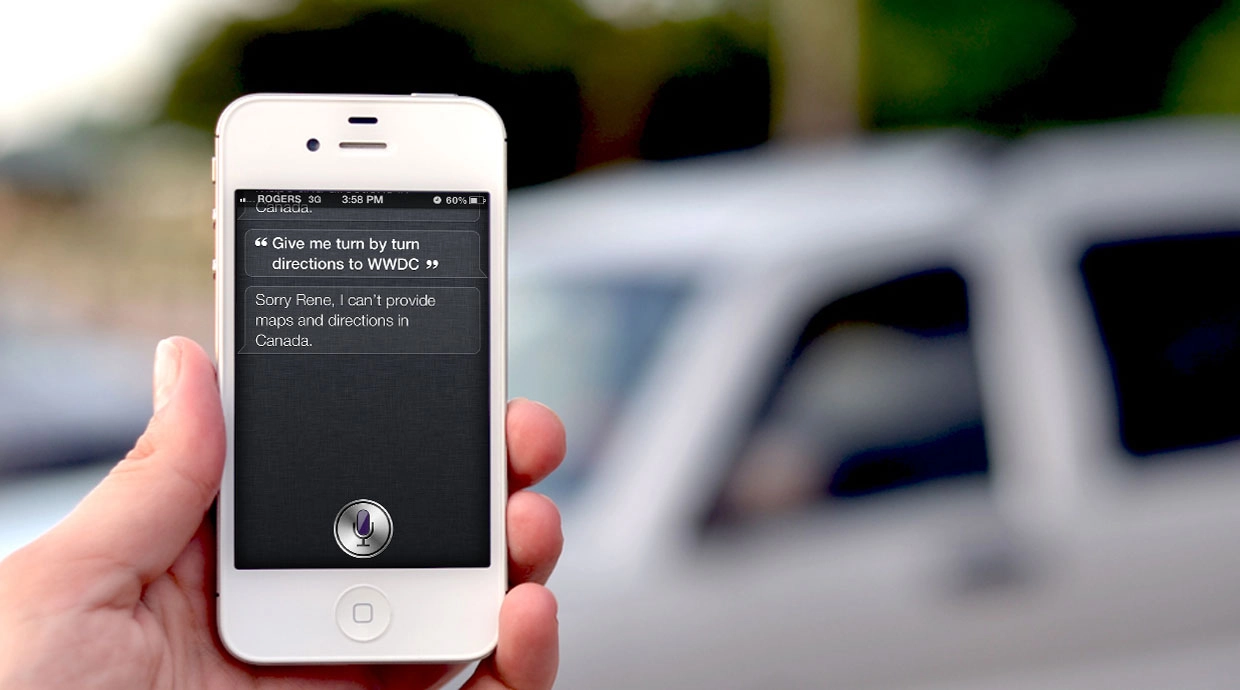
Apple reportedly wouldn't integrate Latitude into iOS Maps, and Google reportedly wouldn't give them Navigation. Street View came to iOS but the vector tiles didn't. Driving, walking, and public transit routes, and alternate routes, appeared. And Google collected and monetized the data that was returned from each and every query.
That's a problem for Apple. As much as Google was Apple's partner at the original iPhone launch, they are now Apple's biggest, most heated competitor.
And Apple reportedly wants Google off their phone (seriously).
That's also a problem. For Apple to reproduced all the work done by Google from Maps launch to today would be non-trivial. Even for a company with $100 billion in the bank, it would necessitate a herculean effort.
But Apple's been planning it for a while.
Placebase
In July of 2009, Apple bought Placebase and integrated the founder into their Geo Team. As far as I can tell, Placebase didn't have their own maps, but instead focused on innovative ways to integrate a variety of public and private datasets, and layer them over the maps.
Poly9
In July of 2010, Apple bought Poly9. It's not clear to me what Poly9's core business was, but they did surface a product called Poly9 Globe. It was a browser-based 3D geolocator -- essentially a Flash-based web app that looked like a spinning globe and could tell you where things were and exposed APIs to big corporate clients. That sounds like Google Earth style map data visualization technology, however. And since they licensed their maps from others, including Google, there still aren't any maps.
C3 Technologies
In August of 2011, Apple bought C3 Technologies. What C3 Technologies did, and now presumably does for Apple, is fairly clear. They make photo-realistic 3D map renderings. Think Google Earth, but with real little city models you can move through. Yet once again, this is visualization, and not core map data.
Putting it all together (or taking it all apart)
Placebase and Poly9 and C3 Technologies all add up to a killer way to render maps in 3D and layer interesting information over them.
But Apple still needs the maps.
While Apple turned to OpenStreetMaps for their recent iPhoto for iOS app, I'm not sure OSM could provide the consistent quality of maps Apple would need for a more critical service like iOS Maps. That leaves redrawing maps, the way Google did. Or licensing directly from Nokia or TomTom. Nokia seems unlikely, for the same competitive reasons as Google. That leaves TomTom.
Street View is also not easily duplicated. There haven't been widespread reports of Apple cars or jetpacks photographing alleyways and strip malls, the way there was when Google was in the middle of creating Street View. It's possible Apple hired or licensed out that work, but it's hard to imagine any large scale photo mapping service going unnoticed anymore.
Traffic data is another factor to consider. Apple says they collect traffic data but has never been clear if that's network traffic, actual roadway traffic, or both. In many ways, however, Apple has the ultimate crowd source at their disposal -- hundreds of millions of iOS users with GPS reporting their locations in cities around the world.
Public transport directions would have to be replicated or likewise licensed. And the list continues to grow.
More than features, reliability and accuracy will be far more important concerns at the outset. That's true both for users, who rely on it for mapping, and developers who rely on the APIs that call it to give users mapping in other apps.
The Google-fed Maps app is imperfect and hasn't seen any significant feature upgrades in years, but it's really good. There's a high bar for Apple to clear, and again, Maps are core technology now. Having bad maps is like making bad calls or dropping communications. Apple has to clear that bar, quickly and convincingly.
Apple did launch iCloud last year, so they're perfectly capable of deploying data intensive new services. But how many, and how fast?
Arguably iCloud didn't launch feature complete. iTunes in the Cloud and iTunes Match rolled out over time. Documents in the Cloud is still waiting on Mountain Lion before it'll work in Apple's own iWork for OS X. And new services like photo and video sharing, and new Reminders and Notes web apps are rumored to be coming just as iCloud hits its first birthday.
No company, not even Apple, can do everything. And certainly not all at once. Time and effort spent in one area can't also be spent in another. When Apple was rushing to get the original iPhone out, they pulled engineers from OX S and Leopard was delayed.
It doesn't seem likely Apple would pull engineers from Mountain Lion, iCloud, or Siri to catch up to years of Google Maps development.
iOS 6 Maps
What seems likely with iOS 6 Maps is that Apple will do what they've historically done -- relaunch with a subset of next-generation features that don't do everything the previous generation does, but do a few things in an entirely new and better way.
The original iPhone was like that. It didn't do everything the Palm Treo or BlackBerry did, but the capacitive multitouch interface was so good people bought into it anyway, even if they grumbled a bit while doing so. The new versions of iMovie and Final Cut Pro X have both been like that. Amazing, visionary new products missing key features of the older versions, made slowly better over time.
That strategy worked magnificently with the iPhone, passably with iMovie, and the jury is probably still out on Final Cut Pro X. The iPhone has such a great multitouch interface people were willing to wait for the missing features. iMovie and FCPX are niche products that, while frustrating, don't frustrate the mainstream. Maps will.
Given the limits of time and space, it seems the most likely scenario of Apple Maps is basic mapping functionality, amazing visualizations, and perhaps some cool additional data layers.
Some features could be U.S. only, or major markets only, at least at first. Certainly, some will have to make for visually exciting demos on the WWDC stage, and later in iPhone 5 commercials.
"Siri, give me turn-by-turn directions to 1 Infinite Loop", rendered like something straight out of Pixar, would certainly fit that bill.
And that's pretty much all I'm expecting from iOS 6 Maps. Not a feature-for-feature replacement of the current Google-fed Maps app with pure Apple tech and polish, but something with a lot of eye-candy, that over time adds back the most important features and introduces new ones. And eventually, maybe by iOS 7 or iOS 8, a damn good mapping solution.
Addenda: Google Maps redux
What will be interesting to see is if Google, free of the shackles of Apple's built-in Maps, submits their own Google Maps app proper to the App Store. Given the brouhaha over Google Voice, Apple would almost certainly have to approve it. (It might even be in their best interests to approve it, to take the pressure off Apple Maps in its early days.)
If that happens, iOS users would actually be better off than every before -- pure Google and pure Apple maps apps to choose from, or to alternate between. The best of both worlds (or both companies mapping the world).
Additional resources
- iOS 6: The multi-billion dollar balancing act
- iOS 6: Higher hanging fruit
- iOS 6: A fresh coat of paint
- iOS 6: Is it time for Apple to revamp the multitasking fast app switcher?
- The 16:9 iPhone
- The 4 inch iPhone
- How Apple could provide direct document access in iOS 6
- iOS 6 and the opposite of widgets
- Is it time for Apple to revamp the Home screen?
- The challenge of bringing Siri to the iPad
- iOS 6 and privacy: How Apple should draw inspiration from Android for better app
Some of the above spun off from a chat with @markgurman of *9to5Mac, so credit where it's due -- though he may or may not agree with the rest of it*
iMore Newsletter
Get the best of iMore in your inbox, every day!
Rene Ritchie is one of the most respected Apple analysts in the business, reaching a combined audience of over 40 million readers a month. His YouTube channel, Vector, has over 90 thousand subscribers and 14 million views and his podcasts, including Debug, have been downloaded over 20 million times. He also regularly co-hosts MacBreak Weekly for the TWiT network and co-hosted CES Live! and Talk Mobile. Based in Montreal, Rene is a former director of product marketing, web developer, and graphic designer. He's authored several books and appeared on numerous television and radio segments to discuss Apple and the technology industry. When not working, he likes to cook, grapple, and spend time with his friends and family.
-
Seems like a nice long way of saying, don't get your hopes up.
All your points are valid though. It took years to get all the data required to power google maps and to replace it doesn't take just money, it takes time. And Apple has to use that time to get a better product ready.
Rene...it almost seems as if you know something we don't. A preemptive strike from possible backlash maybe??? -
A few notes:
Apple's Maps solution will likely use Load Balanced, Redundant Servers hosting the Geodata in Random Access Memory as "Shards" similar to iCloud (which alredy serves more than 100 million users) this will enable Apple to provide frequent, incremental improvements to their service as well as offer their service in non-traditional (for Apple) markets (automobiles?). This is based on original patent research never reported previously except on comments in another forum.
In addition to the Apple location database services used in Apple Maps for iOS for several years Apple Maps likely uses a Categorized, Location Popularity Index to improve search requests. This is based on original patent research never reported previously except on comments in another forum.
According to his LinkedIn profile, Apple has hired Ethan Sorrelgreen, formerly of NextBus which is known for realtime transit data. This is based on original research never reported previously except on comments in another forum.
According to their LinkedIn profiles, Apple has hired Scott Dudgeon and Valerie Yakich previously of Inrix, provider of traffic information, directions and driver services. This is based on original research never reported previously except on comments in another forum.
Nokia Maps 3D solution is provided through C3 Technologies and appears to provide street level views; however, the street level views are the result of street level photography from NavTeq similar to Google's effort. As Nokia Maps 3D continues to use the C3 Technologies solution they either had a mergers & acquisition clause or more likely have partnered with Apple to reciprocate services.
Prior to Apple's acquisition of C3 Technologies (approximately one year ago), C3 Technologies had already developed 3-diminensional models of more than 100 cities, including; Barcelona, Berlin, Boston, Cape Town, Chicago, Copenhagen, Florence, Helsinki, Las Vegas, London, Los Angeles, Madrid, Melbourne, Miami, Milan, New York, Oslo, Prague, Rome, San Francisco, Stockholm, Sydney, Toronto, Venice and Vienna.
Much of the data that provides the various features in Maps for iOS is not derived from Google:
The companies listed in iOS 5's legal notices include the following diverse companies under the "Map Data" section:
• CoreLogic offers Parcel data which marks boundaries for of properties to provide positional accuracy in location-based solutions.
• Getchee provides location and market data on China, India and Southeast Asia.
• Increment P Corp provides location and traffic data for Japan.
• Localeze provides local business listings.
• MapData Sciences Pty Ltd. Inc provides mapping data for Australia and New Zealand.
• DMTI provides postal code data for Canada.
• TomTom offers global TeleAtlas mapping data which is also licensed by Google for their map solution.
• Urban Mapping provides in-depth neighborhood data such as crime, demographics, school performance, economic indicators and more.
• Waze offers real-time maps and traffic information based on crowd sourced data. -
I only read part of that long reply but I think you're missing one key thing: map usage will be considerably higher than Siri or iCloud. Apple hasn't had the greatest track record of managing online services and maps is one where downtime is not acceptable.
-
Needing a data connection is a dumb move. Google maps allows caching. Witch is great if your about to go off road, or hiking in the wilderness. Download the map area, however big you like, and go. Also no street view with be a mistake as well. A beautiful UI means nothing if the actual product sucks.
-
There is no indication that Maps will not temporarily cache data.
There is no indication that a street level view will not be available. Furthermore, there are many navigation solutions that do not provide street level views. -
Is there evidence that Street View WILL appear?
Given Rene's points, this seems the more necessary point to substantiate. -
Do you have any evidence supporting the conclusion that "map usage will be considerably higher than Siri or iCloud?" What measurement is used; data requirements; number of users; etc.?
-
While it's true that apple has released party finished but stable services in the past, they can't do that for maps. They need to duplicate the entire maps functionality of the current app or their new map app will be a downgrade, with a vaporware promise of changes "soon" which could be many months or years down the road. And the userbase of maps is far bigger than those who had the paid version of mobile me or who use imovie. And while the original iphone had weaknesses compared to some of the competition of its day, it'd be very strange to introduce a weakness in a key area of functionality in an established product, when there are strong competitors much closer in functionality to the iphone compared to what was available then.
I'll be very interested in the capabilities of the new map app vs the current and soon to be introduced upgrades to google's maps. I'm sure they'll be lots of spin for and dutiful applause from the friendly WWDC attendees, but the real story will come out during the beta period. -
Not hard data, but considering that 300 million iOS devices can access Maps, and 8 million can access Siri, the odds lean heavily that way.
-
As has been said, anything short of the full (iOS) functionality of Google Maps would be extremely disappointing, whether Apple lets Google submit a nav app or not - but especially if NOT or if Google's not ready to submit, at the time of launch.
-
I used to be suggested this blog through my cousin. I am now not certain whether or not this put up is written through him as nobody else recognise such detailed approximately my problem. You're incredible! Thank you!
-
No street view is a major killer for me. Personally I'd rather they stuck with Google because if Apple's own location service tells me anything I think their maps will be horrible.
-
Renee, as always, a thorough and well written article. I do have to agree with the poster above though. This seems like a very detailed pre-excuse article aimed at lowering expectations.
The good news for IOS users is that you dont have to rely on Apple Maps. There are fantastic third party applications in the App store that can help pick up the slack. This is where Apples OS6 and its ability to allow cross app sharing to become mission critical. Those third party apps will need to be accessible from Apple maps and from Safari. If you can launch into TomTom from a web search with your destination pre-loaded and ready to route, it will bring a functionality that has been sorely missing. -
The one thing I see as "sorely missing" in smartphone navigation apps is making use of 3rd party/personal custom POI (point of information) collections. I have several I've made for myself and collected for use on my Garmin Nuvi - and the first app that makes use of them fast and easy will win my devotion. It's the last thing that keeps me using the Nuvi.
-
I create contacts as points of interest and save to a contacts group so i can navigate to them anytime in tom tom or any other third party navigation app simple drop pin wherever create contact and boom you have a poi thats not locked to any particular app :).
-
Not a bad thought... but for many of what I have in the Nuvi, all I have is the lat/lon coordinates and the Place name.
-
Fwiw, Google Maps is already accessible via Safari. It's just not as convenient as a dedicated app.
Third party, free mapping solutions just aren't Google Maps - otherwise, they'd be on top. And if they're not free, we'll still feel that something's been taken away from us.
Luckily, the jailbreak is already in-effect, so there will probably be little reason, other than Siri, to update the iPad New for a while. And I'm not giving up jb for Siri.
I already stopped updating my original iPad. And the iPhone probably (hopefully, really) won't need to be updated.
So, I can keep using Google Maps. Kinda odd to have this kind of loyalty for something that lacks turn-by-turn directions. -
I hope this allows SIRI to actually work properly in Canada.
-
excellent post Rene, I hardly ever use street view it is mainly gimmicky for me. i love tom tom and infact dont use google maps at all unless i have too with the addition of facebook integration i enjoy tom tom more then ever i would love to see apple partner with them and make a apple style app with tom tom features and mapping.
-
I wonder about older devices though? Surely older devices (but still available) like the iPhone 3GS and iPad 1 generation won't get the iOS 6 update. What happens to the Maps app there? Will Google continue the deal with apple only for the older devices? Will Apple be ok with having two different solutions for mapping based on ios version? Or will they issue an iOS 5 update with only the maps app updated?